Deforestation: Geospatial Data Sharing Protocol to boost supply chain transparency and reduce impact
In a global initiative to foster transparency in supply chains linked to deforestation, Preferred by Nature and the Food and Agriculture Organization (FAO) have announced completing the first step in developing a Geospatial Data Sharing Protocol (GDS Protocol).
In a global initiative to foster transparency in supply chains linked to deforestation, Preferred by Nature and the Food and Agriculture Organization (FAO) have announced completing the first step in developing a Geospatial Data Sharing Protocol (GDS Protocol). Developed under the auspices of the Forest Data Partnership, the data sharing protocol is designed to standardize the transfer of geospatial data, aiming to reduce the negative impact of global agroforestry commodities.
The GDS Protocol is developed to address the challenges of varied geospatial data handling across different businesses. By providing a consistent framework for sharing such data, the protocol facilitates improved assessments related to deforestation and advances product traceability. While it functions as a voluntary standard, its guidelines can assist companies in meeting evolving regulatory demands, including those posed by the EU Deforestation Regulation (EUDR).
The Protocol sets out specific criteria which emphasize the importance of attaching data to tangible goods transactions, employing unique identifiers, and ensuring systematic data structuring. Additionally, it promotes the use of spatial indexing systems to optimize data access and interpretation.
Feedback from stakeholders, including certification schemes and corporations, has been integral to the protocol's development. Their input has helped shape the tool, ensuring its adaptability across diverse business operations.
Peter Feilberg, Preferred by Nature Executive Director, commented on the protocol's potential impact, stating, "With the GDS Protocol, we anticipate a harmonization in data capture practices, which can contribute to more sustainable supply chains." Rémi d’Annunzio from the FAO added that the Protocol could be a significant aid to businesses navigating market and regulatory requirements related to geospatial and sustainability data.
With the first version of the Protocol now released, Preferred by Nature has expressed its commitment to continuous improvement. Plans include real-world testing, further engagement with stakeholders, and exploration of potential integrations with other relevant initiatives and tools.
For a comprehensive overview of the Geospatial Data Sharing Protocol, individuals and businesses can refer to the official webpage dedicated to this initiative.
What is the Geospatial Data Protocol
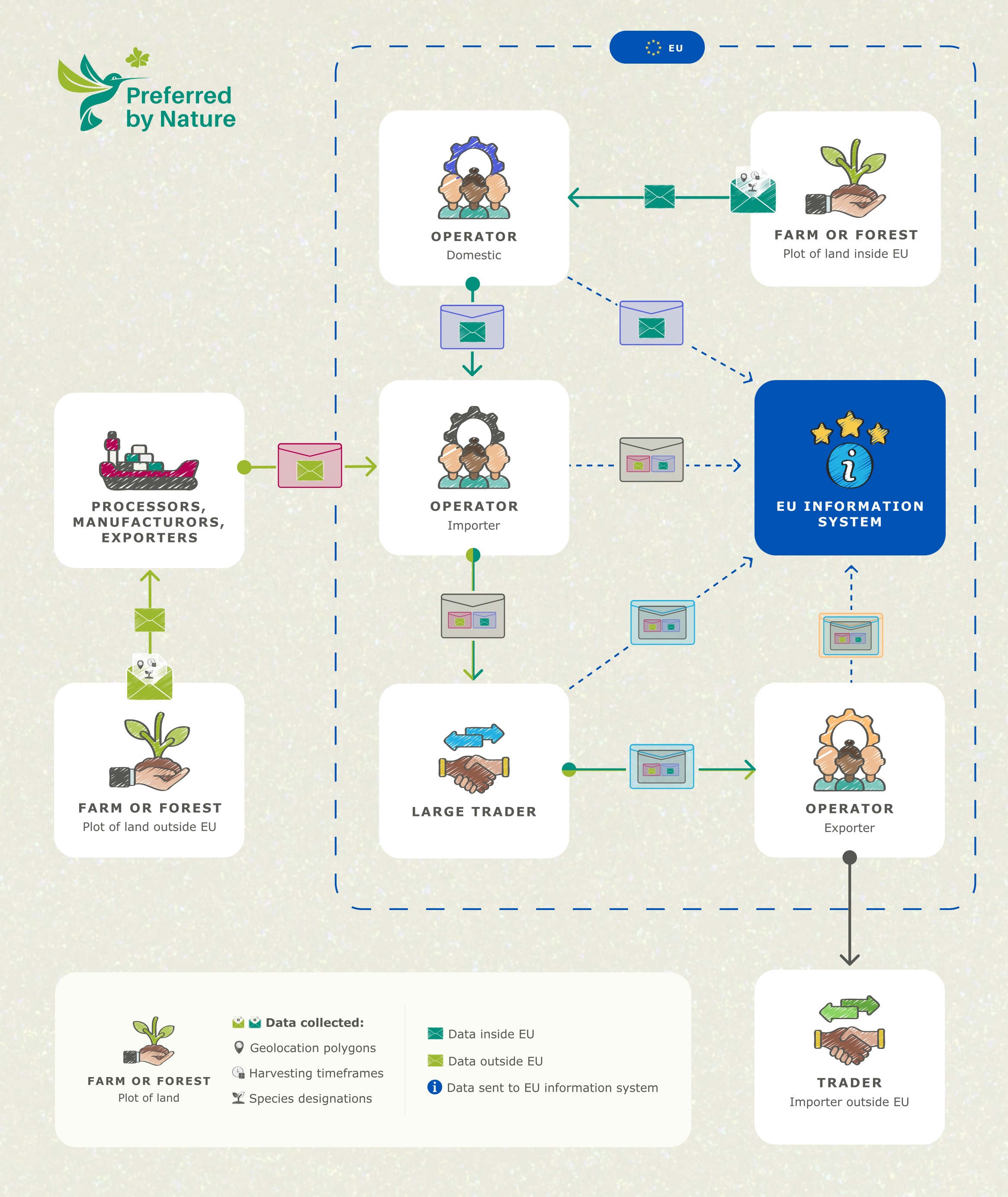
The Geospatial Data Protocol, developed within the Forest Data Partnership, is a set of standardized rules for collecting and sharing geolocation data in global supply chains. It aims to enhance transparency, sustainability, and compliance with regulations, such as the EU Deforestation Regulation. This protocol streamlines the exchange of geolocation information, making it easier for companies to responsibly source raw materials and understand the journey of their products from origin to market. This is an example of how the Protocol would work, and support information sharing, in the specific EUDR context:


